


Mid-Ocean Live Update
Current Position: 16 24.72 N 024 47.19 W Click to view map.
Distance sailed since last post: 31 nautical miles. View the map of our voyage track here
Caught some fish today – sushi for supper anyone? on our way from Mindelo to Santiago
(Sent by InReach satellite connection)
Happy 2017! Just arrived in Mindelo
Current Position: 16 53.14 N 024 59.52 W Click to view map.
Distance sailed since last post: 39 nautical miles. View the map of our voyage track here
Our new year started with some serious hiking and awesome sailing.
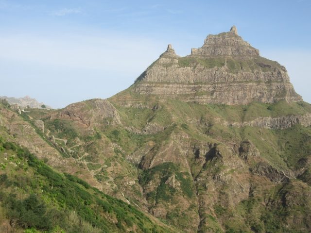
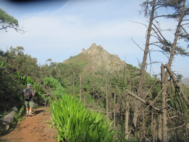
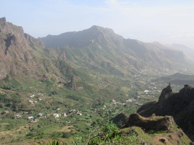
In Sao Nicolau we did a 15 km hike which seemed like it went vertically up and then vertically down. The scenery was spectacular, but our quads were certainly suffering by the end.
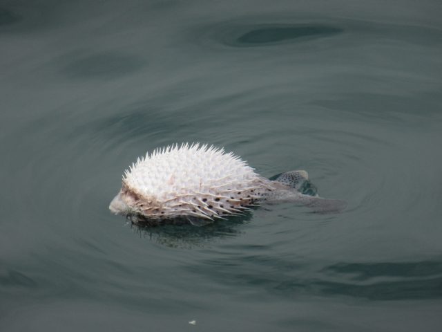
When we got back to our dinghy at the harbour, we found this strange creature swimming about! The locals call it pico which means thorn. To us it looked just like a porcupine swimming – but it is a fish!
Then we had a nice fast 25 mile reach to the deserted island of Santa Luzie, where we did another up and down hike – to try to loosen up our sore legs, and then a swim on the deserted sandy beach.
And today we had another, slightly slower, sail for another 25 miles to take us around the corner to Mindelo on Sao Vicente. The sun was shining, and the sea was smooth. Unfortunately, unlike the day before, today we did not catch any fish. Oh well.
On arriving in Mindelo we were greeted by a German boat who told us that two days ago his boat had been burgled. And that three dinghies have been stolen this season so far. Hmm. Not very encouraging. And the marina wants to charge 47 euro a night. Plus water and electricity. Needless to say, we are staying out at anchor. At least the water is clean and swimmable, and the weather is warm. Ah, so nice to be in the tropics!
We are here to do our final preparations, and waiting for Roger to arrive on the 8th. In the meantime we will try to figure out how to go and visit Santo Anton without having to pay an arm and a leg to do so. Sounds like some nice hiking over there.
So, our year is off to a good start. We do hope that yours is too!
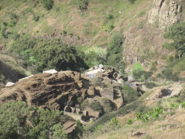
Abandoned village where Ceu picked a nice ripe papaya she enjoyed on the way
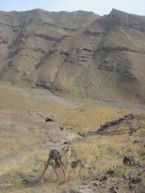
That’s me, trying to assist my legs with the climb. Ceu likes to point out that she is ahead of me already.
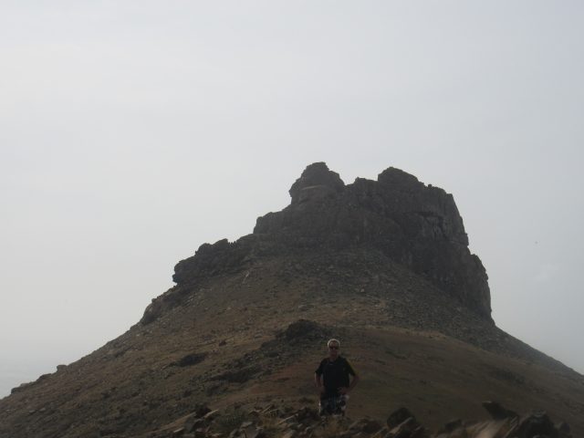
He made it !
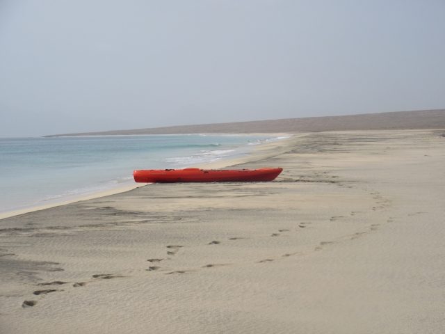
Kyaked ashore. Beautiful, long beach all to ourselves. Loved Santa Luzia anchorage
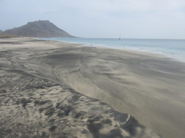
Isn’t it cool how the black and white sand mix together? The mountains are black volcanic, so we think the sand has been blown across from the Sahara. That is Life Part 2 all by herself in the background.
In Tarrafal
Current Position: 16 35.04 N 024 23.34 W Click to view map.
Distance sailed since last post: 82 nautical miles. View the map of our voyage track here
Had a fairly slow sail across from Boa Vista to Sao Nicolau and now having a great time here.
Quite different scenery. Very mountainous. Had a nice tour around the island in a taxi. Now just chilling out by our private beach.
Ben and Jess leave tomorrow, and then we have a week before Roger arrives and we are ready to set sail for Barbados.
Just Arrived in Sal, Cape Verde Islands
Current Position: 16 45.3 N 022 58.8 W Click to view map.
Distance sailed since last post: 420 nautical miles. View the map of our voyage track here
Had a fast trade-wind sail. Blue skies, not to much in the way of waves, but lots of speed. Did the whole trip in 66 hours – 6.8 kt average, door to door (well, anchor to anchor).
We are now in Sal, and will be here for a week, as Ben arrives next Monday. Already got internet sorted out, so that is good. But I think we are anchored around a rock, so I guess I need to dive down and have a look at what is happening there.
The party this evening is on the neighbouring Dutch boat, who arrived about half an hour after us. Sounds good to me 🙂
On Our Way to Cape Verde Islands!
In the end we decided it was too much of a rush to visit the Casamance area of Senegal. So, instead, we are sailing straight to Cape Verde islands tomorrow. We are aiming for Sal, the upper right island, where my son Ben will be joining us in a week or so to stay for Christmas.
As per usual, we will update you all once we arrive there AND get internet sorted out. Though we may also send a brief message at some point by our Satellite text message gadget. The trip should take us 3 days.
Tips for Sailing The Gambia River
Current Position: 13 23.67 N 016 37.41 W Click to view map.
Distance sailed since last post: 97 nautical miles. View the map of our voyage track here
Cruising The Gambia presents a few challenges to the sailor that are a bit different from most other destinations. My hope is that these few tips might make it all a bit less daunting. They are presented in no particular order.
Navigation
Download our navigation package and install the GPX routes and Google Earth images (kindly provided by fellow explorers Rick and Joyce on S/V Full Tilt) into OpenCPN. Most of the time you won’t actually need them, but they are nice to have, especially when the real river does not match the chart. Also get hold of the “Cruising Guide to West Africa” by Steve Jones, published by the ROYAL CRUISING CLUB PILOTAGE FOUNDATION. It is available as a PDF if you search online. It is now 20 years out of date, but still has useful comments. What is clear is that the commercial usage of the river, already diminishing when Steve was there, has now completely vanished. The only traffic we ever saw was one other yacht and a few fishing canoes.
The Gambia is a HUGE river, and the land is very flat – the highest point in the country is near to Baboon Island and extends maybe 50m up. Yet, despite the flatness, the river is actually very deep – usually at least 6m, often over 10m, and this depth goes right up to the river banks.
There were two areas that were shallow. One is on the approach to Lamin Lodge, just outside of Banjul. The GPX track shows the route for that, or one of the locals will, no doubt, be glad to guide you. The other was on the northern branch of the river as it passes the Deer Islands. Exiting that branch on the way upriver we saw a minimum depth of about 2.5m.
Having said that, remember that this is a river, so the inside bank of the bends can often be shallow, as can the corners of creeks or branches of the river. Stay midstream and you will have no problems. You will usually be able to anchor in about 2-4 m, sometimes deeper. You will almost always be lying to the tidal current unless there is an unusually strong wind, so there is not problem going close to the bank, though the insects may be worse there.
The river turns to fresh water round about Elephant Island. Until then it is all pretty much mangroves and fairly monotonous. Once the water sweetens, the vegetation (and insects) change, and you may start to see some wildlife. Once you have fresh water, fill up some buckets and soak all your salt-encrusted and stiffened lines.
Allow 14 days if you just want to go up to Baboon Island and turn around. More if you want to go farther, or explore the creeks. If you want to visit a village, remember that this will probably mean you miss half of the tide and you won’t be able to depart again until the next day.
Medical
Make sure you have your medical stuff up to date including various immunizations (Yellow Fever – which now lasts a lifetime, not 10 years as before, Hepatitis A & B, Tetanus, and Malaria pills – we used Meflaquine). Take whatever prescription medicines you need, including doctor’s notes if needed for customs. Also this is a good time to review your first aid kit and restock the items that are out of date. You will be in REMOTE Africa, and there won’t be any doctors, nurses or pharmacists anywhere near to where you are. So whether it is diarrhoea, injuries, pink eye, allergies or whatever, you are on your own. It might be many hours before you can get to a hospital or clinic. You MAY be able to find last minute supplies in Dakar, but don’t count on it.
Checking In
You can check in only during working hours. If you arrive outside of those times anchor off and come ashore in the morning. If it is a weekend go and anchor up at Lamin Lodge, and come back when they are open on Monday.
When you take your dinghy to the pontoon, you will probably be greeted by someone who will want to show you around. You don’t need them. They will expect a gift if you do accept their friendly offer.
Walk along the pontoon to the shore. Then keep walking in the same direction. You will pass through a gate, where they may ask to see your passport and will write down your name. They are friendly. Then keep walking until you come to the main road, where you will turn right. Keep walking until you see a big arch, on the right, saying Port Authority. At the entrance you will see some security. Ask them to show you where the immigration office is.
We decided to pre-empt the bribe question by immediately giving the officials in each office some chocolate as a gift. For immigration we then presented our passports and boat papers. They did NOT ask to see the checkout from our previous port which, in fact, we did not have as we had given what we had to Senegal. We were using our Canadian passports, as that was where we had our Gambia visas. For Senegal we had used our European passports. We had checked in at Dakar, but had not checked out of Senegal anywhere. No worries at all. The process was friendly and quick. No fees. They will photocopy your passports. Ask them to make you an additional copies, plus your boat papers, for immigration.
After immigration you go to Customs. This takes longer. You will have to fill in a form, and they will want photocopies of your passports and boat papers. If you don’t have any, they will send someone to make some, for which they will want some money. They will accept Senegal CFA for this purpose.
After some time waiting around for all that paperwork, the Customs official will announce that he needs to come aboard the boat to inspect. Once he walks around the corner with you he will suggest to you that it is a lot of hassle to go onboard. This is your cue that he would like a gift and that, having received the gift, he will get your papers stamped with no more ado. We were with another boat’s crew, so decided to give him 2,000 CFA (about 4 euros) each. I know, don’t say anything.
The next stop is the bank to get some Gambian money. It is a bit of a walk across the whole town – just keep on walking along the sea front – until you find about four banks, all of which have ATM’s and will also change Senegalese CFA. Alternatively many street vendors will change CFA for you at a less favourable rate (eg 350 Dalassi = 5,000 CFA compared with 372 Dalassi in the bank). The cash withdrawal limits at the ATM’s seem to be 3,000 GMD at all the banks. Some ATM’s charge for the service, some don’t.
The final stop is the Port Authority for the cruising permit. We had to wait an hour for him to come back from taking depth soundings in the harbour. Once he returned, the process was pretty quick. The fee was 22 euro, but has to be paid in Gambian Dalassi. He will write out a cruising permit, and will give you the rules for visiting the Baboon Islands national park. Once you have this, you are done. The whole process takes some time. If you run out of time, and the next office closes, just come back when it next opens.
Internet
Like most of Africa, 3G internet is actually quite good and cheap. We used Africell. In Banjul, and also at the airport, there is an Africell store. Go there to get the SIM as you will need your passport to register it. Get them to make sure it is all working on your phone. To get data you need to first buy credit, and then dial 120 to convert that credit into Giga Bytes. When we were here, it was only 275 Delassi (about 5-6 Euros) for 1Gb. You can NOT buy credit using your credit card over the phone. To buy more credit go to a local store (available in most villages but not all) and buy additional Delassi-worth of credit using cash. Get them to apply the voucher to your phone number. You should receive a text confirming that. Then dial 120 again and convert that credit into Gb. Once we had it all working on our phone, we then took the SIM card out, and put it into our unlocked Orange Airbox wifi router. It worked well. However, Skype, WhatsApp and Viber are blocked here. If you can get a VPN to work, then you can get around that, but we were unable to get a VPN to connect. Hopefully with the new President this situation will improve.
Most villages along the river have a signal, but often your internet connection will only be Edge, and thus slow.
Make sure you turn off the updates on your computer, or set your connection as a ‘metered connection’ otherwise you will blow all your Gb on updates instead of emails.
Food
Everyone has to eat, so you would think that food would be readily available everywhere. Not so. Like going on a long passage, stock up well before you arrive in Gambia. In Senegal there are some big French supermarkets such as Carrefour and Auchan (Atac), but that means going in to town and they are expensive. Once in Gambia you will only be able to buy imported foods – eg cans, condiments, packages – in the Banjul area, and they are expensive. Even garlic is imported and expensive. In Banjul and surrounds (eg Westfield and SeneGambia) there are several supermarkets that do stock imported foods, and in which you can buy pretty much everything you want, but you are still better off provisioning before you leave the Canaries.
Once in the villages do not expect to be able to buy ANYTHING. In most villages we could not buy eggs. In none could we buy milk, though we did find some expensive small cans of evaporated milk in one village. In the dry season, (November to March) ALL food is severely limited. You might be able to buy some onions, potatoes (Irish or sweet), and maybe a few tiny eggplants (aubergines). Apart from watermelons in Kantaur, we did not find any fruit of any kind for sale. No tomatoes. We had hoped to buy some bread in one village, but the baker had decided to take the day off, so no bread was available. We did buy 2kg of flour instead – for 6 euros.
So what do they eat? Mostly it seems they eat rice and ground peanuts. Together this makes a nice porridge. I don’t know what else they eat, apart from fish. We did see a number of goats around, and also chickens yet, as I said, we could rarely buy any eggs – and when we did, they were far from fresh. To test the eggs, float them in water. If they sink, they are good. If they float, they are not fresh – but may not yet be rotten. Be aware that in Banjul the eggs may have been stored with the smoked fish, and may therefore acquire a fishy smell. The ones from the supermarkets are fine and fresh.
One food that you CAN buy, pretty much anywhere, is fish. In fact, when you see a fisherman in his canoe, go over and offer him a bottle of cold drinking water. He will be very grateful and you will have made a friend. Most likely he will also give you free fish, or invite you to join him for lunch.
If you ask the locals if there ‘is a market’ in the village, they will no doubt say yes, and will take you to a hut in which the women is selling some stuff, or else they will take you to another woman who has three aubergines, some pumpkin and one onion for sale.
Gifts
The villages you will be visiting are VERY poor. They really do have NOTHING. You will be shocked, and will feel sorry for them. Don’t. The vast majority are happy and content with their lives as they are. The politics and ethics of aid for developing nations is complex, so here is my brief take on it:
When you visit the villages you will be mobbed by children. In some villages they will even swim out to your boat. For this reason I suggest that you anchor a few hundred meters away so you can have some privacy. Once you go ashore, you will be mobbed. They will repeatedly ask you your name. They will all want to hold your hand. You are the most exciting thing that has happened in the village since the last boat passed by, maybe several days or a week ago. So far, so good.
In the villages that get more tourists, whether by land or by boat, the children have been trained (by previous tourists) to expect gifts. They will ask for handouts, either money or gifts. If you give it to them, you encourage that behaviour and, before long, it will be like Dakar where you can barely walk three steps before being accosted by someone who is very ‘friendly’ but actually just wants a handout. Yet they are very poor, and you feel sorry for them, so what should you do? If you feel that you want to give something, go and visit the school. Speak with the teachers or principal, and see what they need. In many villages only half of the children attend school. A big challenge, therefore, is to motivate them to attend. For that reason, we decided to give gifts only to the school. We gave some school supplies (pencils, rulers, sharpeners etc), and we gave some skipping ropes (spare lines that we no longer needed on the boat), and a couple of footballs. We also gave some un-needed clothing and shoes, and entrusted all of these with the teachers to use them wisely.
Footballs are a much requested item by the boys. By giving them to the school, along with skipping ropes for the girls, we are empowering the teachers to make school more fun and thus more attractive to the children. Come to school and you can play football.
If you give the football to the boys in the village, though they will enjoy that a lot, it erodes the possibility for encouraging them to attend school.
As for sweets and candies? Sure, they will enjoy the gift, though they won’t actually appreciate it all that much, and you will simply reinforce the expectation that tourists bring gifts.
Buying Things
Whether you are buying goods or services (eg. taxi rides, or work on your boat), ALWAYS negotiate the price first. The more experience they have of tourists, the more the price will be inflated for ‘your’ benefit. You may think the price quoted is cheap in euros or dollars but, most likely, even after negotiating you will end up overpaying.
But if it is ‘cheap’ why does that matter?
Most people live on maybe a dollar a day. Those that have actual jobs may get paid a handful of dollars a day. So now you come along and you overpay him a couple of dollars for some small item or short taxi ride. In his eyes that would be the same as you being overpaid by $50 or $100 back home. So if you can earn that much just by hassling a tourist, why would you want to work hard somewhere else?
In Dakar this has reached epic proportions. Here is a very typical example: We are crossing a busy road. In the central divide there are some wooden boats that are being built. Immediately he sees us, a man approaches us, very friendly, and tells us how he is building these boats and aren’t they lovely? We are cool but polite. We tell him we are crossing the road to get a taxi. So we cross the road. He crosses with us. We then hail down a taxi. He pushes in front of us and starts to negotiate with the taxi driver on ‘our behalf’. He tells us the taxi fare will be 3,000 CFA (Senagalese Francs). We know the correct fare is 2,000 CFA. Eventually I manage to push the guy aside and tell the driver that I will give him 2,000 CFA, take it or leave it. When I get in, I tell him, in French, to not give the other guy anything. As he drives off, he tells us that the guy claimed to be our friend, and wanted the driver to give him the extra 1,000 CFA as his commission for negotiating on our behalf. Had we not know the correct fare, had we not known some French, we could easily have assumed the guy was being helpful and friendly, and we would have overpaid by 50%. AND, no doubt, the guy would have asked for a handout before leaving us.
In Banjul we had exactly the same experience with someone who ‘negotiated’ for us the price of some vegetables in a market. An argument even erupted, in their native tongue, between two such negotiators who were competing to act, uninvited, on our behalf.
The other common tactic is to become your uninvited tour guide, to show you around, and then to ask for money at the end. Having got wise to this, and having thought it through, we now refuse to give anything at all, unless it is negotiated in advance. At times you have to actually get quite rude to them to get them to leave you alone.
All of these problems are the result, not of their poverty, but of previous tourists paying too much and giving away free money and gifts. Don’t do it.
As I said, in the small villages that are rarely visited these problems are much less, and people are genuinely friendly. The kids there really do just want to hold your hand.
Tides
You will be travelling up river with the flood tide and down river with the ebb. Forget about trying to correlate this with tide tables from anywhere. Look out your window. If the tide is flowing in the right direction, use it. When it stops and turns, anchor. In about 6 or 18 hours you will be able to get going again. Usually you will get about 1 knot of current, at times it will be as much as 3 kts. In general, the tide turns later up river than it does at the river mouth. If you are going upstream, add 1.5 to 2 hours to today’s times. On the way down add maybe nothing. On some days you may get the end of the tide in the morning and then the beginning of the tide in the late afternoon. The tide runs faster in ebb than in flood, as it is augmented by the river’s natural flow.
At Lamin Lodge there is a sandbank that sailors often use for beaching their boat to do bottom scraping. Local labour can be hired cheaply for this.
Weather
November and December are dry season. At this time every day is hot and sunny, though some days may have some cloud cover. The stars at night are bright and beautiful. There is no wind. Do not expect to actually sail up or down the river; you will be motoring the entire way. Likewise there is not much breeze for dispelling insects.
In Lamin Lodge we had heavy dew each morning, but never had it again on the entire river cruise.
Earlier in the year I guess the weather is different, and both rain and winds are much more common.
Bugs and Insects
You will be astounded by how many different types of insect want to eat you. Yes there are mosquitoes (though actually not that many in the dry season). There are also tiny ‘no-see-ums’, tsetse flies (which carry disease), and a whole host of other biting insects of various shapes and sizes. Plus there are moths, earwigs galore, praying mantis, and who-knows what else. Every day the boat is covered with the bodies of multitudes of insects. I don’t know why so many die – maybe it is just the natural turnover of their brief lives. As you work your way up the river you will discover ever different species of insects to torment you.
Insects are attracted to lights at night. You will see a cloud around your anchor light, plus a bunch of bats feeding off them (Go, Bats, Go!). If you turn on lights in your cockpit or salon, the insects will come. But it gets dark at 19:30 hr, so what do you do? Here are the tactics we used, in combination – and we still got bitten in abundance:
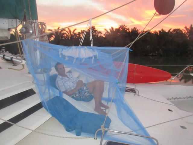
1) A mosquito net. We bought one in Banjul market for 375 delassi (7 euro). Get one with the four corners for tying on a four-poster bed. It makes it easier to set up a ‘tent’ for yourself in your cockpit or on the foredeck. Get this set up before sunset, as that is the worst time of day. Unfortunately there are plenty of tiny insects who fly right through the netting. Still, you may be able to enjoy your sundowner, and perhaps supper, inside your tent. If you can bring one of those actual camping net tents that might be even better. Ideally soak your netting in DEET insect repellant in advance.
2) A mosquito coil. You can buy these in any village. They are a black or green flat coil, about 6 inches diameter, that gets put on a little stand. You then light one end of it, and it burns slowly like a cigarette, producing a smoke that is supposed to repel and kill insects. It does work for mosquitos, but not wonderfully for other bugs. Put this under the table when you eat, to protect your legs. Perhaps put it in your cabin before you go to bed, but it does smell.
3) Insect repellent. Get a good supply of it. The key ingredient is DEET. We actually found one that came as a rosemary scented lotion and was actually quite pleasant to use. It did work somewhat.
4) Clothes. It is hot, so wearing more clothes is not an ideal solution. But at times it is the only one that works. Long sleeve, long leggings, and socks and shoes. Better still, have two layers, eg a T-shirt underneath, as the insects will be happy to bite through your clothing wherever it is in contact with your skin. A hat helps too.
5) Keep your cabin door and windows shut. Do everything you can to prevent insects from arriving in your cabin. If you seal it off completely, it will work, but it will be too hot to use. If you have screens over your windows and hatches, that helps, but the little ones still get through. Once you turn on a light, they will come. If you want to read in bed, turn on a bright light in the bathroom so as to preferentially attract them over there. Maybe put a coil in there too. Try to avoid putting lights on. Use a fan. Cover yourself in bed with at least two layers of sheets.
6) Lights. Don’t use them, as they attract the insects. Of course that is impossible, so if you must have a light on, perhaps have a brighter light nearby so as to preferentially attract them over there. Blue and white attract more than yellow and red. Try using just your red headlamp. Insects will cover your laptop screen; try putting that outside the mosquito net.
7) Anti-histamine cream – in England, sold as Anthisan – works well to reduce the itchiness of recent bites. Put the cream on instead of scratching them, as scratching will just make them worse. If you do that, you may then end up with infected bites, which are not uncommon in the tropics. An alternative is hydrocortisone cream, but that should be used sparingly. If it gets really bad, then an oral antihistamine might help too.
Water and Fuel
One thing that has changed in the past 30 years is that the villages now have clean piped water to village standpipes, which the women collect daily in plastic jerry cans. It may be a bit of a trek back to your boat, but if needed you will be able to get fresh water in most villages. If you are nervous, you can always boil it before you drink it.
Fuel is available in Banjul. At the same dock where you come ashore to check in, there is a diesel fuel pump. You will need to have someone from ashore make the arrangement with the Port Authority to allow you to tie up to the dock. Then you will need to speak with the fuel station farther up the road, on the left, just before you come to the main road.
Then bring your boat to tie up to the dock. Make sure you inspect it first from land, so you know what kind of fender arrangement you want to use. We used a fender board. Keep in mind the tidal stream that flows past the dock.
Once you are tied up, the guy from the fuel station will come and fill you up. This is a commercial pump – ie very fast – so be careful that you don’t overfill. We used a funnel and had him pump very slowly. The diesel seems to be good quality. They will also fill up your outboard’s fuel tank if you carry it up to their station.
And the good news is that this fuel station is WAY cheaper than the ordinary fuel stations on the roads.
Your other option is at Lamin Lodge where the boat boys will organise jerry cans and get fuel for you from the fuel station in Lamin. This will cost a taxi ride, and the fuel is more expensive than in Banjul at the dock.
Swimming
On the coast north of Banul are a number of tourist hotels and some nice beaches. It is worth a taxi ride to go for a day on the beach and enjoy some surf. Ask for Sene-Gambia, and walk through the fancy hotel to the beach. If the northerly swell is not too big there is some fun to be had body-surfing in the waves. The beach is long. Closer to Banjul is the Palmerina beach, and nearby to that is the Maroun supermarket, so you can combine a beach trip with a super market run.
Once you go up the river you won’t be swimming at all. The water is brown with mud the entire time and, no doubt, like most African rivers probably harbours various nasty parasites that you can do without collecting.
Wildlife
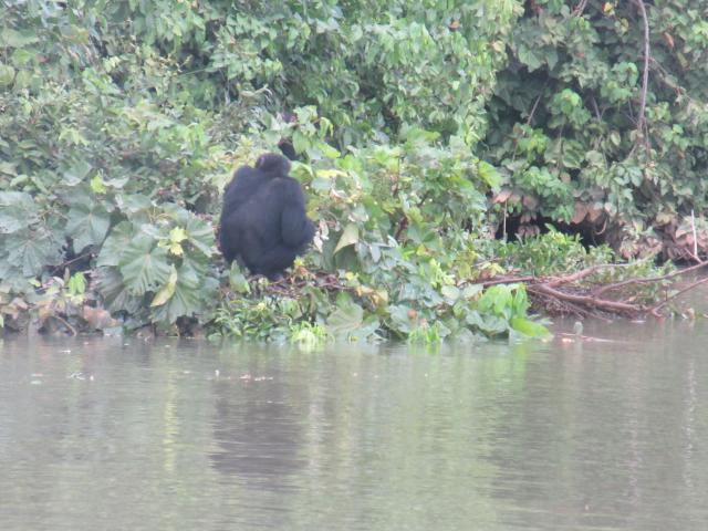
This is the reason you go. The Gambia is a paradise for bird watchers. We don’t fall into that camp, but saw many eagles, herons, egrets, pelicans, kingfishers, vultures and so on. We also saw hippos, several different types of monkeys, including baboons, red colobus and, of course, we saw the chimpanzees.
You will start to see the monkeys from about the Deer Islands. They are not plentiful, but they are there. Look in the branches of the trees, especially the palm trees that have a fruit that looks a bit like coconuts, but is clearly not a coconut tree. We saw a number on the north shore of the northern branch of the Deer Islands. There are several different species.
Hippos are hard to spot. Unlike in Uganda, where there are dozens lounging around in the water and on the river bank, in full view of the tourists, here they seem to hide. From the Deer Islands upwards keep your eyes open. A friend saw some in the cross-over creek between the two Deer Islands. We saw some a bit further upstream, actually swimming across the river. We also saw another one that quickly walked into the river and submerged. They hide well, and stay under water a long time. When they come up, they take a big noisy breath, and then submerge again. If you see them, you will probably see only their ears, eyes and nostrils above the water. However, at night, especially by Baboon Island, you will hear them all around you in the dark. Do not approach them, they are dangerous.
Chimpanzees live on the Baboon islands. They can’t swim, so actually they are trapped on the island which is therefore really a huge zoo. Even so, they live there in the wild, supplemented by the rangers – and here is the secret – that come and throw fruit to them around about 16:00 to 16:30 each day. At that time the chimps, and the baboons, will come down to the water’s edge to collect the gifts, and will then climb the nearest branch to sit and eat it. After a while they will retreat to the inner parts of the island and will then be hard to spot again. Try to time your trip through the baboon islands to coincide with this feeding schedule. But keep quiet and stay mid-stream, or the rangers will come and talk to you.
We also saw one head, which we believe to be a turtle, that was intermittently popping up to see where it was going as it swam across the river.
There are no warthogs, water buffaloes, impala or other deer. The last elephant was seen in the 1960’s. There are wild pigs which, for a fee, will be captured for you for supper. The Gambia is a Muslim country, so most locals do not eat pork. However there are enough Christians around that occasionally a pig will be caught for them. If you are lucky enough to hear about this you may be able to buy a chunk of the meat for your fridge. Be warned that the meat almost certainly carries parasites – make sure the meat is well cooked before you eat it.
Lamin Lodge
About 4 miles up a creek from Banjul is a popular and peaceful well-sheltered anchorage. There is a rickety lodge ashore that does some nice lunches. There are also a host of ‘Boat boys’ who will offer to do jobs for you – everything from providing you with a taxi, to cleaning the bottom of your boat, or getting 300 litres of water for you by donkey. These men are friendly and can be very helpful. Just make sure that you negotiate, and are clear on, the payment terms before you start anything. Suleyman and Baks seemed to be our favorites. If you want to leave the boat while you travel somewhere else, this would be a secure place to leave it, especially if you negotiate with someone to keep an eye on it while you are gon.
From the Lodge it is about 3 km walk along a sand road to the main Banjul highway at Lamin Village, on the way there you will pass through the village. At the highway you can flag down a minibus ‘car’. You will pile into this with a bunch of locals, and will pay just 8 Dalassi to go to Traffic Light. From there you can get another such ride to SeneGambia where you can visit the beaches. Compare that with 500 Dalassi (or more) to get a private taxi. On the other hand, you can get a taxi right there from Lamin Lodge. Just agree the price first. If you want, you can basically hire them for the day to drive you around on various errands.
There are two types of taxi – the standard, yellow and green ones, and the tourist taxis, which are plain green. The latter are more expensive but tell you that if you leave something behind in the taxi, you will get it back. Hmm. The ones in Lamin Lodge are the green ones – or else just one of the men’s private cars. Taking taxis everywhere gets pretty expensive, so I recommend braving the bus system – it is fine once you have done it once.
Of Hippos and Chimpanzees – Cruising the Gambia River
Current Position: 13 36.28 N 014 58.65 W Click to view map.
Distance sailed since last post: 94 nautical miles. View the map of our voyage track here
Banjul is a delightful contrast to Dakar. It might be the capital of this tiny country with its 1.8 million inhabitants, but it feels more like an over-grown African village. There are no high rises. in fact, there are barely any big buildings. Like all the villages, the roads are packed dirt, the stores are just large stalls, and the traffic is light. In fact, most of the traffic consists of big trucks that are delivering or picking up supplies for onward distribution. Banjul is, after all, a container port that receives about one container ship per day, plus the occasional cruise ship.
Having completed half of our check-in when we arrived on the Friday afternoon, we then had the weekend free until we could get our cruising permit on the Monday. On Saturday morning we moved from Banul up a shallow creek to Lamin Lodge, a sheltered anchorage and the site of a ramshackle establishment, run by an ancient German, that serves surprisingly good food. We were entertained during our lunch their by overhearing an English dad explain to his sons why one should never spend less than 900 pounds to get a decent pair of binoculars and, if you can, you should really spring for the ones at 2,500 pounds to get the really good ones. Hmm. How will we ever manage with our Bushnells?
For Gambia is the paradise for twitchers. Don’t come here for the scenery. There are no mountains. Or even hills. The country is one big mangrove swamp that merges into freshwater wetlands. Rice is a popular crop, grown, like in China, in paddy fields that are flooded by the freshwater tides.
But it does have birds.
Now, don’t ask me what kind of birds they are. What I do know is that you hear a lot of them. And you see them. There are certainly eagles, hawks, vultures, kingfishers, egrets, herons, flamingoes, pelicans, and countless others of different shapes and sizes whose names I have no idea.
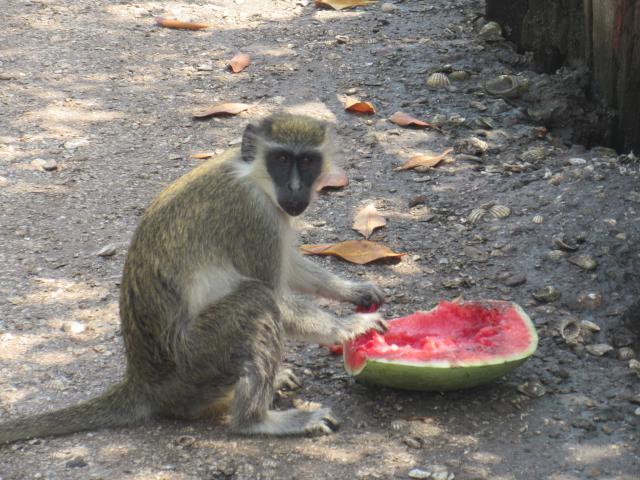
But I digress. We are in Lamin Lodge, learning about the inadequacies of our Bushnells binoculars, but enjoying a nice meal and a cold beer. And a nice cooling breeze. Afterwards we walked around the Lodge locally and met some of the monkeys that are attracted there by the offer of free watermelon.
Being a mangrove swamp, there are also lots of oysters that attach themselves to the mangrove roots. These, it seems, are harvested not just for food (actually, they are quite hard to use for that, because of how they grow all clumped together), but mostly for their shells which, being calcium carbonate, can be burned and then slaked (watered) to turn into ‘slaked lime’ – calcium hydroxide – from which one can make cement. Which is exactly what the locals do. So one sees large piles of oyster shells all around the village, waiting for processing.
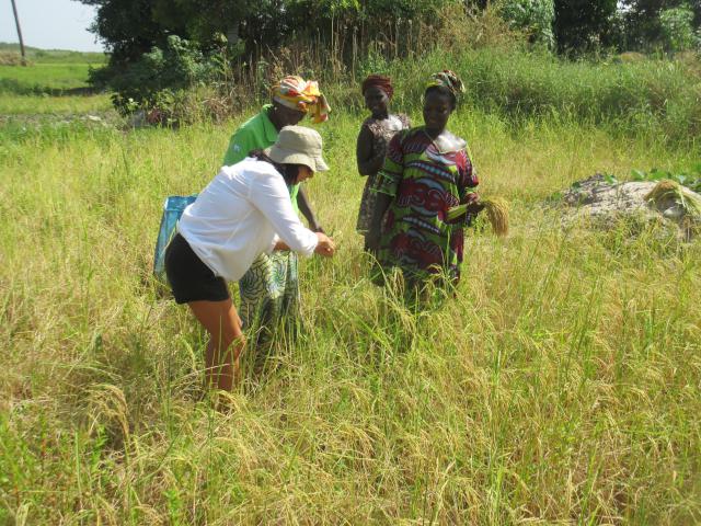
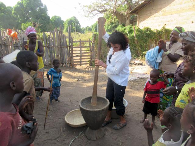
Ceu, being herself, was quick to join in with some women who were harvesting rice. This they did, not with a scythe or sickle, but with a small kitchen knife, with which they would cut off a few stems of rice at a time. Once they had a handful, they put it in a basket.
Sunday was spent sorting out internet for the phone. Having been told it was just a couple of kilometers from Lamin Lodge we decided to walk. 5 or 6 Km later, very hot and dusty, we arrived at the outer entrance to the airport grounds. There we met a very pleasant security policeman who had nothing better to do than to drive us up to the airport itself where we were able to sort out our internet (see our tips on Gambia).
For the tourist the main attraction are the beaches just north of the city. So on Monday, after getting our cruising permit, we hit the beaches. How nice it was to have a swim in the sea again! It is not the Caribbean, but we had some great body surfing. A lot of fun.
And so on Tuesday we headed up river.
When we left Banjul we had company. There was a French yacht, with Mum, Dad and teenage daughter who were also going up the river at the same time as us. This was the only yacht we ever saw on the river. As they were travelling at the same time as us, we kept meeting up with them at various stops, and would then compare notes on the wildlife we had seen.
Our first stop on the river was just 15 miles from the start. James Island, now called Kunta Kinteh Island after the character in the book and movie Roots by Alex Haley. Like Goree Island by Dakar, this was a staging post for slaves being shipped to America. Kunta Kinteh was a local who was captured and enslaved. Now the island is just a ruin, and the nearby town is also pretty underwhelming, though there is a Spanish lady there who is trying to help get it built up more so as to attract tourists. We anchored outside that town, while the French anchored off the island.
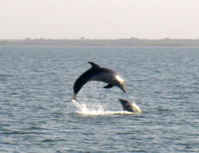
Before and after James Island we were treated to some spectacular displays by dolphins. These were hunchback dolphins, and they would leap into the air like we had never seen wild dolphins do before. And so many of them!
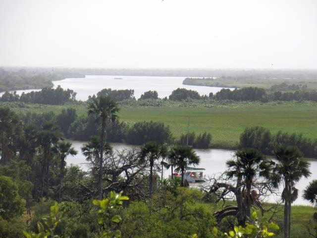
The Gambia River is huge – over a mile wide for much of its cruising length. But it is still a river, so it is a matter of catching the tide going in the right direction, and then anchoring until the next tide. In this way we meandered about 140 nautical miles up the river, going gradually from saltwater to freshwater – but still brown mud all the way.
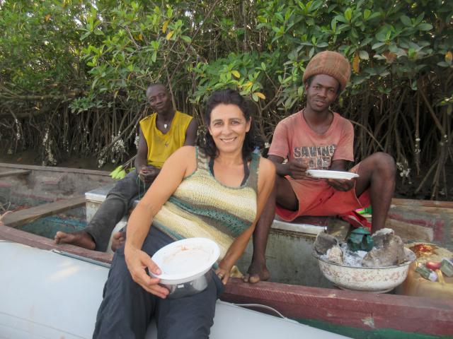
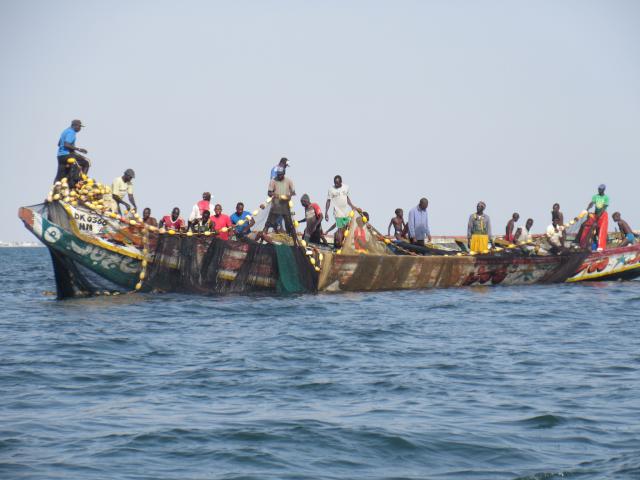
Several times we went in the dinghy to say hello to the fishermen. All were friendly. We gave them a bottle of cold water and made friends for life. One boat invited us to join them for lunch, which was spaghetti being cooked in a pot on a charcoal fire in their wooden canoe. We contributed some bottled sauce that we had, and also some pasta salad. And gave them a spark plug, as theirs was not working. Immediately one of the guys installed it and got his outboard running again. A different boat gave us some fresh caught fish.
Their fishing tactic is to string fishing nets all along the side of the river, close to the mangrove. This seems to work, as we saw many small (8 inch) fish caught up in the nets. I don’t know how the fish manage to find each other for feed, as visibility in the muddy water is a matter of inches only.
So Rural, So Remote
We also visited some of the villages. Gambian villages are RURAL. They do, now, have piped clean water coming to a village standpipe, around which all the women gather to fill up their plastic jerry cans. Apart from that, they have very little. In the dry season it seems they mostly eat rice, ground peanuts, and fish. Though we did see plenty of goats and chickens, very few of the villages actually had any eggs for sale. And much to our surprise, fresh fruit and vegetables were also almost impossible to get, though we did find some potatoes and aubergines.
Visiting a village is a Big Event for the locals. The children are particularly excited and will mob around you, clamouring to ask your name and hold your hand.
The poverty is obvious. People have nothing. But they are cheerful and friendly. Daily living is clearly hard work – pounding rice, collecting water, farming and fishing.
But when the work is done, they sit about the village and socialise with each other. It reminds me of the parable about the peasant fisherman who is encouraged to turn his small fishing activities into a growing and big business – so that ultimately he can retire, and then can sit around and perhaps do a bit of fishing. “isn’t that what I am doing right now?” was his response.

A rice and peanut porridge is a common meal – and very tasty too!
And so we must be careful not to impose our western ideas of success and happiness on these people. What we noticed was that in the villages that are rarely visited the people were all welcoming and friendly. But in the more visited villages they would be asking for gifts and handouts. Sure, they were still friendly. But now one starts to suspect their motives when they come to greet you. The extreme result of this was, of course, Dakar.
A popular request from the boys was for a football. They all want to be Christiano Ronaldo. We did buy two balls in one of the larger towns, Kantaur, and we then took this, plus some spare lines as skipping ropes, plus a few school supplies, and gave them to the teacher at one small village. He will use them as incentives to get the children to attend.


Just a walk through the village of Bombale, near elephant island. Where there’s music there’s dancing. Ceu joined in. No English speaking. The next day we found out it was a naming ceremony
Most of the lower stretch of the river is mangrove, so a bit monotonous on the scenery. But from Elephant Island up it started the change – as did the insects who were trying to bite us.
At Kudang we anchored right outside the village – and quickly regretted it. We were surrounded by children in canoes and even swimming. Some of the little ones could barely swim and had to hang on to our boat when they got there. One teenager just calmly climbed on board and started to walk into our cockpit! We were so overwhelmed that we picked up the anchor, moved on half a mile, and anchored again. We never visited that village again.
Each day we traveled about 20 miles, hitching a ride with the tide while it ran, and anchoring when it stopped. Sometimes this would mean a morning trip and other times we traveled in the evening. The former was nicer, as it allowed us to stop in the afternoon and still enjoy the day before the bugs came out in the evening.
The evenings were a challenge. The bugs were so plentiful that we tried multiple strategies to try to escape them. We set up a a mosquito net ‘tent’ on our foredeck, and would crawl under this at sunset – even eating our supper there a couple of times. But still the tiny insects can get through the netting. If there was a breeze it was better. Most of the time, though, it was flat, flat calm. So still. In the lower stretches there were no sounds. Just a red sunset, starry sky, and bugs. Up river was more noise – cicadas and other insects making noises. So many birds chattering away. And Hippos grunting like pigs.
Wild Life
At Deer Island we started to see monkeys. There were at least three different varieties that we saw. Not easy to spot them, up in the trees. So we decided we would go ashore, as there was a nice accessible beach there,and see if we could see more inland. As it turns out, we had a nice walk through the savanna and brush, but we saw no more monkeys.
Coming back to the boat, however, we did meet some fishermen who were extracting fish from their nets. So we gave them some cold water, and they gave us some fish that we then ate for supper.
We were still hoping to see hippos. The fishermen told us there were lots around. The French said they had seen 3 just by Deer Island. But so far we had seen none. Finally, as we were approaching Baboon Island we saw one, who quickly walked into the river and submerged. Yet at night at anchor just up from Baboon island we heard them all around us. There would be grunting, and loud splashy exhalations. We shined a flashlight into the darkness, but we never saw any eyes reflecting back at us.
The Baboon Islands are a national park. No anchoring is allowed within, and one is required to go no closer to the island than midstream. We arrived late in the day on the Sunday and motored with the tide past the islands hoping to see chimpanzees. We did see a few monkeys – red colobus and baboons – but no luck with the chimps. We anchored just past the last island.

In the morning the park rangers came out to see us. We had a pleasant chat, and asked them about the Lodge in which, we had heard, one could stay and get to see the chimps. And all for only 100 pounds, all inclusive, for a couple. The French family had, it seems, such a booking. That sounded cheap compared to the cost of seeing chimps in Uganda. And since it was Ceu’s birthday, we wanted to know how to arrange this. Alas, the rangers said it all had to be done online – and since we had no internet at the time, that ruled out that option. And then, pretty much as a last thought, they told us that one could gain ‘entrance to the park’ for 150 Dalassi (3 euros) each. Further discussion, including a lengthy conversation between the rangers in their local language, resulted in a very cool outcome. For just 700 Dalassi they would take us in their boat, right up to the edge of the island, and we would find the chimpanzees. They would make Ceu’s day for her.
At 1pm they came over to Life Part 2 to pick us up, and we went chimp hunting. One of the guides would stand in the bow and call out in Chimpanzee, inviting the chimps to come and visit us. To no avail. No chimps, no baboons, no colobus, no hippos, nothing. They were sad. We were sad. But such is wildlife.
Then, after another long conversation in their language, they had a solution. At 3:30pm we should take our dinghy over to their camp. We could then do a short walk through the woods while we waited for 4pm.
At 4pm the senior rangers from the main camp set out with a pile of fruit. Every day at that time they would go to the Island, and they would throw fruit ashore. Needless to say, the chimps and baboons were very happy with this arrangement, and would come down to collect the offerings. This allowed the rangers to count and observe the health of the animals. We, with our private rangers, would tag along behind, at a good distance, and watch the show.
Once the feeding rangers had moved on, we were taken much closer in. And there they were. We stared at them. They stared at us. Then they turned their backs to us, and continued to eat their fruit. The baboons were less sanguine. They would shake the branches at us. So cool. The rangers were happy that we got to see the chimps. Ceu was happy on her birthday.
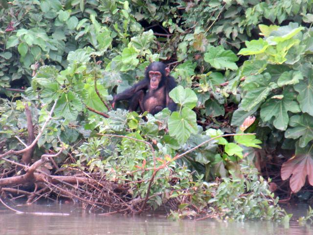

Several times the chimps would turn their backs to us while eating. Quite deliberate.
That then, was the pinnacle of our river trip. We decided to go no farther, as we wanted to leave a few days for visiting the Casamance before we had to head off to Cabo Verde to meet with my son Ben’s arrival.
The trip down the river was quicker. At times we were moving at 7.5 kts as we had the combination of the river flow added to the spring ebb tides. Shortly after leaving Baboon island we say a bunch of hippos swimming across the river. They would poke their heads above the water. Let out a large breath, and then duck underneath again. They could stay below for a long time. No wonder we could never see them.

Before long we were back with the dolphins as we approached James Island and then the Banjul estuary.
We made our way back up to Lamin Lodge, and the next day we beached Life Part 2 on a sandbank so that we could scrub down and reactivate our coppercoating. Actually we were impressed to see very little growth on the bottom, so that is good news. Just a bit of slime that was easy to scrape and rub off.


It turned out that we didn’t really have enough time for Casamance, so we went to the beach again, instead.

The beaches of Senegambia, Banjul. Look who’s 50. Happy Birthday!
And then it was time to go to Cape Verde Islands.
Cruising Dakar and Senegal – Do We Have Stories to Tell!
Current Position: 13 26.37 N 016 34.87 W Click to view map.
Distance sailed since last post: 91 nautical miles. View the map of our voyage track here
It was one small splash for a man – and a barely perceptible splash for Mankind. Ben Hooper waded into the water off the beach in Dakar, dived forward and started swimming. We were there on this historic occasion, as were Reuters and a handful of other reporters. And, in our dinghy, we motored alongside him for a couple of miles, finally letting him go as we reached Goree Island.
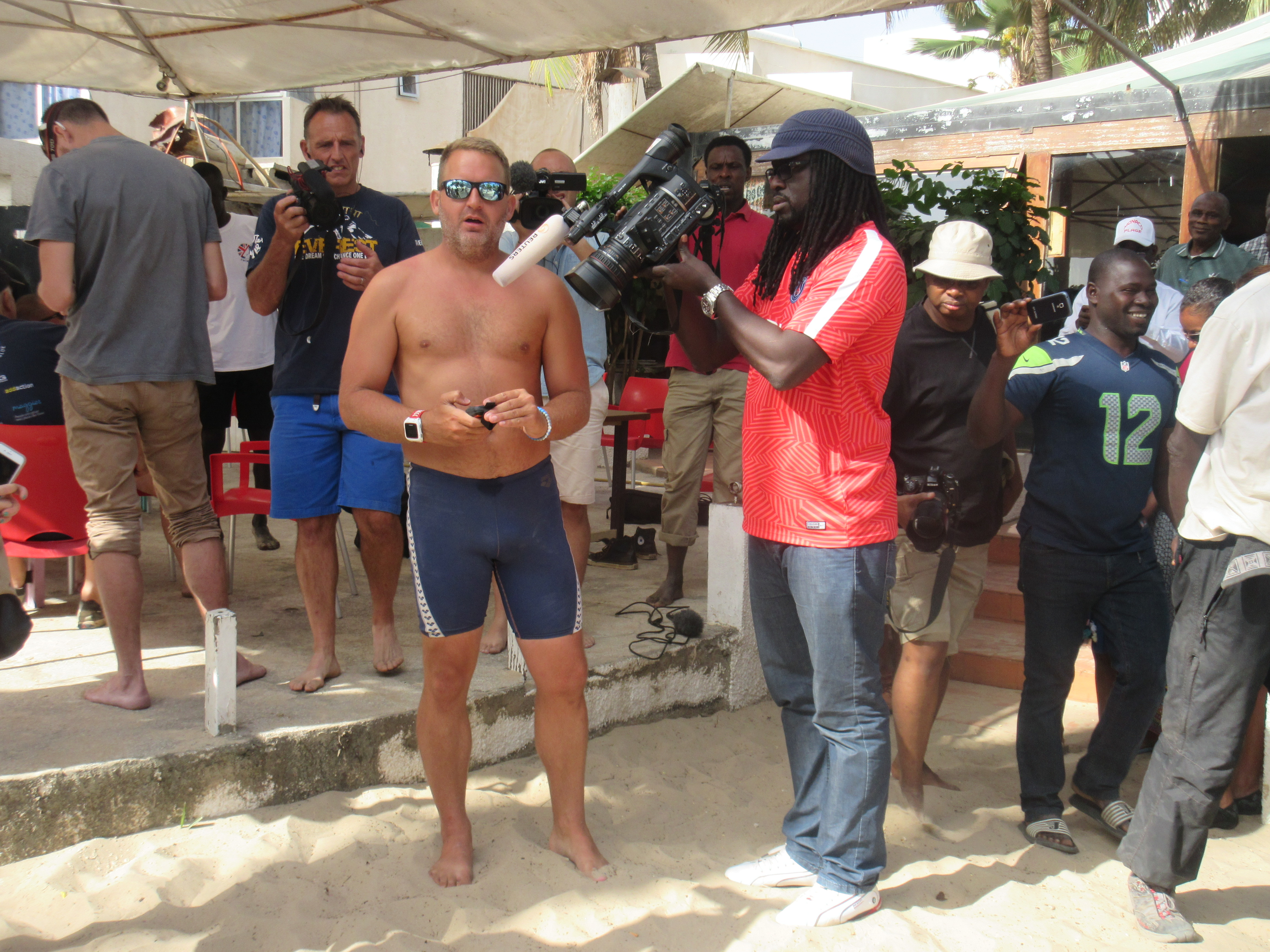
Ben Hooper, just moments before the momentous splash
Ben’s goal was to swim, yes swim, from Senegal to Brazil. 1600+ nautical miles across the Atlantic Ocean in aid of charity. He was the first of many characters that we met when we arrived in Dakar.
We had arrived at night. So in the morning we moved the boat closer in to the shore. There wer several other yachts at anchor so, as per our normal modus operandi, we went around to visit some of them. The first was an old wooden catamaran with SwimTheBigBlue.com written across it.
At first we assumed this was some kind of charter operation. We pulled alongside and were greeted by a friendly face who spoke English and was carrying a big video camera. Shortly we were joined by Ben Hooper who told us two astonishing items of news – the first was his goal to swim the big blue. And the second was that Trump had won the US Presidential election. I am not sure which item was the more shocking – but both were captured on video by the cameraman, Jason.
On going ashore to the Cercle De Voile de Dakar (CVD – the Dakar Sailing Club) we then met Nick and Sally, who own a steel ketch, and their new, temporary, crew member Rob, from Niagara Falls, Ontario. This boat was to accompany the catamaran on Ben’s quest to be the first to swim an ocean.
Unfortunately, Ben had met more than a few challenges in putting together his adventure. Raising funds and putting together a crew for something like this is no mean feat. Not the least was to see two men carrying beams of wood, like Jesus and his cross, through the CVD while the rest of us were enjoying a beer on the evening before Ben’s planned departure. It seems that someone had sat on the tiller and broken it…
Swimming at about 1 kt, the trip would take at least 4 months. Ben would swim 8 – 12 miles a day, and then would rest over night on board. The next day they would zig back to the approximate end point from the day before, and he would swim again. The Guiness Book of Records does not require him to return to the exact spot, provided the total distance swam is the correct amount. One of the big challenges will be to keep the two yachts from going too fast. They will have up minimal sail, and will be using drogues.
As Ben swims, he would have one boat ahead, one boat behind, and a sit-on-top kayak paddling beside him. To me, it sounded fine as long as the seas are smooth, but come some winds and waves, well, I have my doubts. But, wow! What an adventure to be even trying something like that! All power to you, Ben!
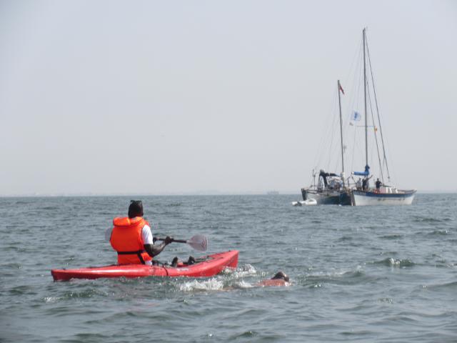
Ben Hooper and his kayaker as he swims the first mile of this trans-Atlantic attempt
As we write this we have no idea of his progress. His tracking device seems to have broken down, so there are no live updates on his website. We hope all is well.
And then we met Kai. Kai is German. But he doesn’t live in Germany. Oh, no. He lives in Liberia. Yes, down there on the bottom left corner of the West African bulge – between Sierra Leone and Cote d’Ivoire – where all the Ebola stuff happened not so long ago. With all the troubles in Syria, and the spill-over of refugees and all that in Turkey, it seems that tourism to Turkey has collapsed and, with it, the price of used yachts. So Kai nips over to Turkey with his 16-year-old daughter and buys himself a nice second-hand monohull sloop which he names YOLO (‘You Only Live Once’).
After we left him, we met a fishing boat pulling in its catch.
And so Kai is doing a delivery trip. He and his daughter are sailing YOLO since June from Turkey around to Monrovia, Liberia, where it will be the FIRST pleasure yacht in the country. Unfortunately Kai had no charts for Liberia – or indeed anywhere south of Morocco. So he was glad to receive from me a set of charts for the whole world that he could use on his openCPN. In exchange he cooked us a nice Liberian meal of grilled snapper, and 3 other kinds of fish, with stewed carrots, cassava and eggplants.
We were also pleased to meet, again, some French friends that we had met in Morocco. The world of sailing is, indeed, a small world. The first thing they did was give us a Dorado they had caught on the way down. Nice.
At CVD which, incidentally, charges you for anchorage, you can fill up with ‘filtered’ water, for a price. We did so, but it has a stale taste to it, so we filled our jerry cans with good water from our tanks, and then filled up the one tank with CVD water. We are using the jerry can water for drinking. Diesel and gasoline are also available, by jerry can, for a reasonable price per liter, plus a price for the guy to carry it to your boat. We filled up on gasoline for the outboard – having used a lot of it to follow Ben Hooper around – but didn’t need any diesel.
The CVD is a comfortable place to bide some time. The beer is both cold and cheap. The company, as you can see, is eccentric and entertaining. But, sadly, the surrounds seriously detract from the experience. Had this been a bay with blond sand and azure waters we might well have stayed on a few days yet.
But it stinks.
Literally.
There is an open sewer that runs straight into the sea right next to the yacht club. The water is filthy and polluted.
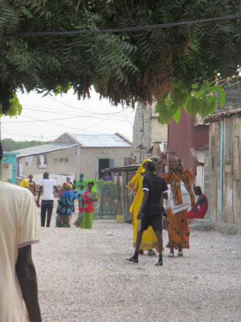
Dakar is even worse. We had three trips into Dakar. The first was by foot – hunting, unsuccessfully, to get a SIM card that would work. The second, on Monday, was to check in with the authorities, after which we walked through the town center to explore. And the third was to specifically visit the northern end which, we had been told, was the nicest.
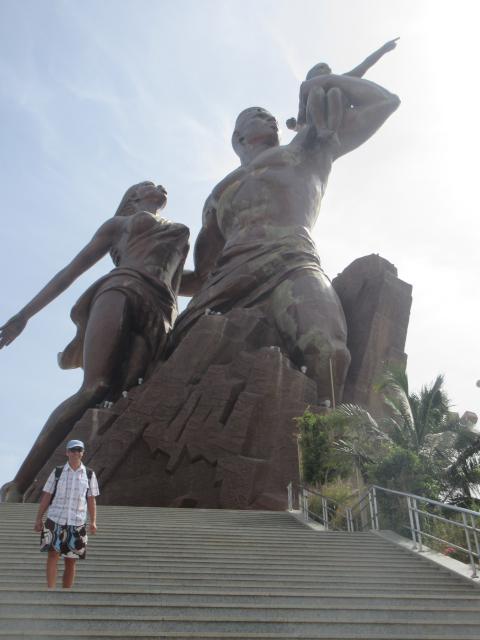
The Monument of Independence is probably the nicest tourist attraction in the city – and, they claim, more visited than the Statue of Liberty
Well, nicest is all relative. Dakar is a dump. It is crowded. It is dirty. The air is polluted. It is, supposedly, the most developed city in West Africa but it has little to recommend it. There are some big French supermarkets, such as Carrefour, Auchan (Atac), and Dias. But even they have limited supplies and are expensive compare to Europe. The market Karmel, near the check in Port, did have some good looking fruit, veg, meat and fish.
One of the ‘beaches’ on the west coast of Dakar
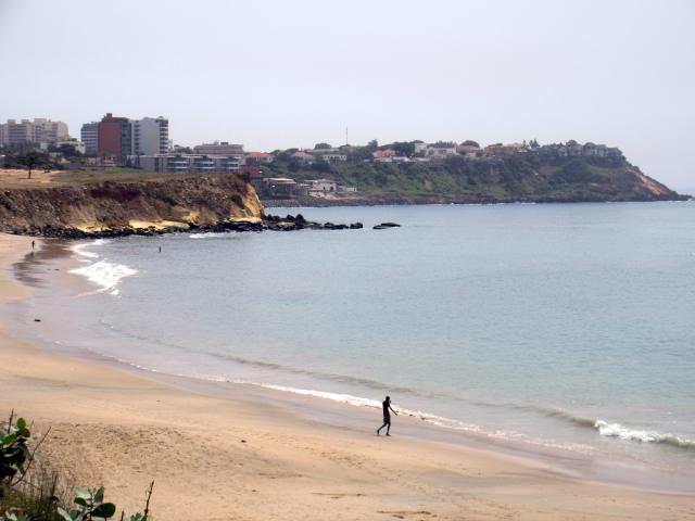
Well, OK, it does have this beach too – but the sand and water are dirty.
But the biggest drawback is the hassle. Walking around we noticed we were the ONLY white people at large. Why was that? Because you can barely walk two paces before someone, very friendly, accosts you and strikes up a conversation. He asks your name, where you are from, and starts to tell you about the sights you are seeing, and should see – and how he will take you there. It is virtually impossible to shake him off. But when you do, before you take another two paces, another one has taken his place.
All of them want a gift of money for being your tour guide.
It gets so that you become suspicious of everyone who greets you, as you assume that all they want is some money from you.
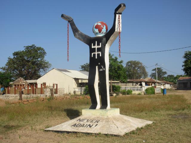
Goree Island, on the other hand was a pleasant visit. Having said farewell to Ben who was still swimming, we took our dinghy across to the island. The water here is beautiful and clear. The island was used in the slaving days as the pick up point for more cargo (ie slaves) bound (in both senses of the word) for the Caribbean and America.
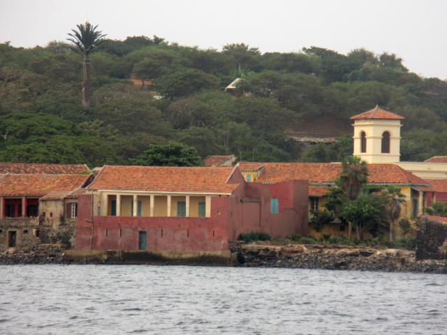
The Gate of No Return from which slaves left the island to board the ships bound for the New World
A sad chapter in the history of Portugal, England, Holland and France. Even here, of course, we were accosted by uninvited guides and then, at the end, had to pay 20 euros for the privilege of parking our dinghy on the broken-down pier.
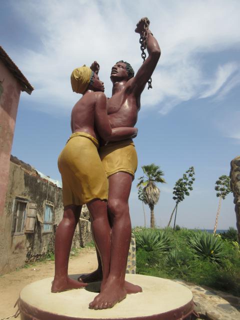
Commemoration of Freedom on Goree Island
The company, and the stories, were fun. But we were glad to leave the stink and set sail southwards for the Gambia.
Unfortunately we departed rather too late in the morning. The winds were on the light side, so speed was slow. Given an early start, and some fresh winds, one can just make it to Banjul in daylight. Clearly that was not going to happen.
So we decided to break our trip to visit the Saloum River. As it turns out, we arrived there in the dark too! But with a bright full super-moon, plus the GPX track of a friend who had gone before, plus our radar, and Ceu’s eagle eyes in the bow, we were able to nose ourselves into the river and anchor in a safe and calm place. The biggest confusion was the plethora of coloured flashing lights in the river entrance – some red, some green, some white – were these channel navigation markers, or what the heck were they? It turns out they were anchored fishing boats. And we managed to dodge them all.
Down town Dionouar
The next day we turned back down the river to visit Dionouar described by Steve Jones in the West Africa Cruising Guide as “one of the most striking towns in West Africa, standing majestically in a natural setting of silver sand and palm trees. The most prominent feature is the central mosque with its impressive minarets.”
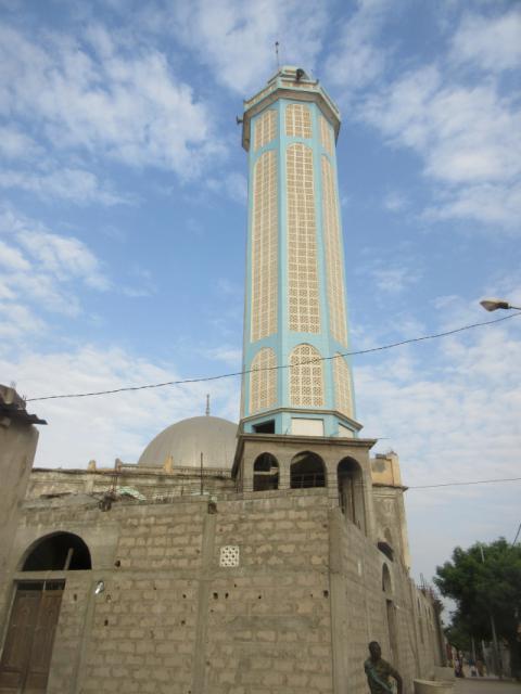
The mosque, with its “impressive minarets” in Dionouar
Really? Did Steve actually visit the place?
The beach was actually dark grey, but looked white from a distance because of all the white clam shells that were all over it, and were also used as paving for the streets. The Mosque did, indeed, have one minaret. The rest of it seems to be still unbuilt. There were some palm trees, but hardly majestic.

Taking jugs of water right across the football field, mid game
The town people were, however, friendly, and did not hassle us for gifts. We visited a baker, who gave us some bread, and we bought some more. A few children gathered round, but we were not mobbed. And the fishermen on the beach were also cheerful and friendly.
A new fishing boat in construction
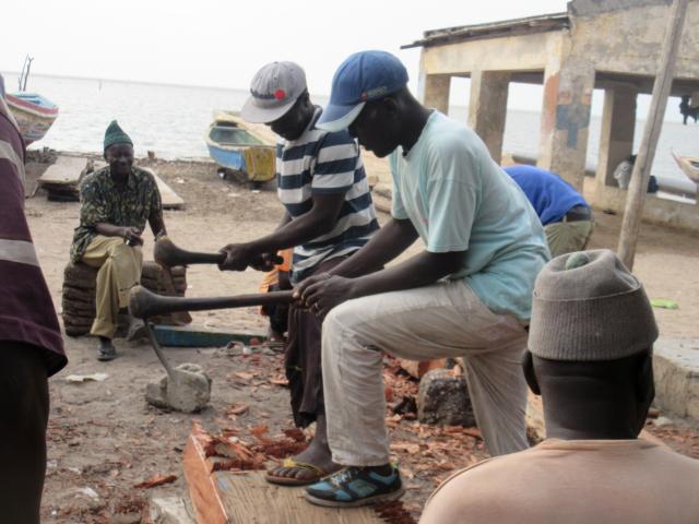
On our walk back we came across some men training for the local wrestling competitions.
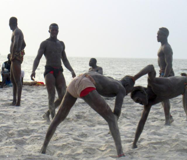
The local wrestling school
The next day we set off early to try to get to Banjul before sunset. In fact, we got the tides right, and we sailed nicely into Banjul at about 2pm. Anchored, and went ashore to check in.
The astute reader will have noticed that we did not check out of Senegal. We have a one-month cruising permit. We would like to visit the Casamance area, but that is south of the Gambia. If we went there first we would then have to beat 100 miles upwind to get to Banjul. No thank you. We will check in to Gambia, then, if we have time, we will go to the Casamance and maybe check out of Senegal at Ziguinchor. Or not. When we reach Cabo Verde we will have our check-out from Gambia in our Canadian passports. Indeed, some sailors said there is no need to check out of Senegal anyway.
Canaries to Senegal – and a Personal Best
Current Position: 14 43.1 N 017 25.66 W Click to view map.
Distance sailed since last post: 4 nautical miles. View the map of our voyage track here
This crossing of 842 miles was like our Lisbon to Morocco crossing – but more so.
We set off with very light winds which, unfortunately disappeared totally for a while overnight. We resisted the urge to motor, but when our speed went to zero and we lost all steerage it is hard to know what to do. Does one just drop the sails and drift until the wind fills in again? Or does one motor, even if slowly, to at lease keep steerage? In the end we opted for the latter.
Even so, we knew the wind was coming. And, sure enough, by midnight the wind had arrived, and we were sailing. Only doing 1.8kts, but at least we were moving and we could steer. Over the next four hours we gybed several times as the fickle wind decided what it was going to do. By 5 am it had finally decided it would obey the forecast. We did a final gybe, our speed went up to over 3 kts, and we were on our way!
Before long we had the spinnaker up, and were creaming along on smooth water at 5.5 kts. The sun was out, and it was simply beautiful.
Gradually the wind picked up, as we knew it would. The spinnaker came down at supper time, and we settled in to our broad reach that would take us all 800 miles to Senegal. This is what trade wind sailing is supposed to be about!
From that point on, there is not so much to say. The wind gradually increased until it was a steady 24kts apparent. By then we were down to our second reef, and still we were flying. The waves were a good 2m high, so that gave us some epic surfing, with speeds up to 14kts briefly. But the real proof of the conditions was our daily average. From 01:00 hrs on Tuesday we were up to speed: a steady 8+kts. We held this speed for almost two full days, giving us a 48 hour run of 384 nm (8 kt average) and a 24 hour best of 201 nautical miles (8.375 kt average). Yes, we broke the 200 nm in a day barrier! Wow! Now is flying!
The wind then decided to drop a little, but the forecast was still for an increase again, so we decided to leave the reefs in for the next night, which then cut our day’s run to about 190 miles – which would previously have been a personal best.
In the middle of one night we were about to meet nose to nose with a Spanish fishing veseel with a closest point of approach, according to the AIS of a few meters. He would not respond to the radio. So, what to do? Normally one would turn to starboard (right) so as to pass each other port to port. But that would mean going onto a run, which I was a bit nervous about in these waves that were tossing us around. The alternative was to harden up and cross his bow to cross starboard to starboard, which we could do with better control. But since I couldn’t confirm that with him, what happens if we wakes up and then decides to turn to his starboard. as he would be expected to do?
In the end I decided to bear away, and we managed to squeak by with only half a mile of sea room between us. It is tricky at night, as it is impossible, visually, to determine how far away a ship is. Fortunately the AIS and radar provide nice reasurance that one is going to miss them.
Finally, as we were just passing him, he woke up and spoke, in Spanish, on the radio. He still had made no effort to change course. I decided to ignore him, as my Spanish is insufficient to swear at him.
So that was our one incident of excitement. Apart from that, it was just FAST SAILING and it looked like we would be on track to arrive in daylight on Friday.
Alas, all good things come to an end. The wind then eased a bit. The sea was smoother, but our speed dropped just enough to mess up our daylight arrival.
But first we had just a little bit more excitement. About three hours before landfall I thought I saw a fish on one of our lures. But when we brought it in, there was nothing. What we did notice, however, was that the hooks were all blunt again! How could that be? It seems these hooks get a bit a rusty and go blunt all by themselves.
So I sharpened them, and put them out again. Sure enough, within an hour we had caught a nice little tuna. Perfect for supper.
And then, just as the sun was setting, we spotted land.
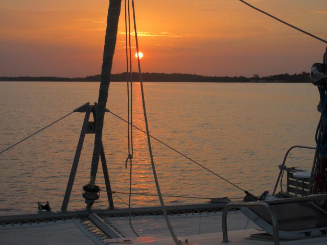
The sun might have gone, but the three-quarter moon was bright in the almost clear sky. We still had 20 or so miles to sail around the point to get to the anchorage, but with such a bright moon, that was no bother at all. We ate our tuna and glided past the Madaleine island rocks, the bright lights of the city, then Goree Island, of slave trading infamy, and round the corner to anchor in 3m a good way off the shore at Hann, where there are two yacht clubs. Thank goodness for GPS and radar! In the morning we would move closer, when we could see better where to go.
So that was it. 842 miles in 5 1/2 days for an overall average of 6.37 kts, including an record breaking 200 nm day in the middle. Not bad, considering our first day was only 80 miles.
And so, after 51/2 years away, Life Part 2 is back in the tropics.
Good Morning from Senegal
Current Position: 14 40.22 N 017 23.09 W Click to view map.
Distance sailed since last post: 805 nautical miles. View the map of our voyage track here
Good Morning all
Welcome to Senegal!
We are so excited to post and tell everyone we had a great trip to the city of Dakar. Took us 6days and 5nights.
I am sure Noel will be, very soon, telling you all about our trip here.
For now, just want to make it quick (and not bore you on your weekend)as I sit here having a cup of cofee and watching the very colourful fishing boats going into shore with with their catch.
It is 8am on this beautiful, warm Saturday morning. Noel is still catching up with some sleep.
I couldn’t sleep in with excitement to see this place in daylight. We dropped anchor last night at 11:40. The city lights were beautiful and we could make out some of their monuments from the sea. Clearly we could see their Monument of Renaissance. With a beautiful 3/4 full moon lighting our way, we were led to our anchorage. Dropped the anchor when we got to about 3m in depth. Had a great sleep.
I see Gore island just 2 or 3 miles from our anchorage. When passing last night, I thought of the history, the Portuguese connection, the slaves and the hard times of all.
This morning we plan (we must) get ashore right away and do this check in business.
Plan to find a WIFI connection and press the SEND button on this post.
Plan to find a place for a new SIM card and get us connected as well. Welcome to the running around in a new country!
Excited to get connected with Skype…
Excited to visit this city…