


Fixing up Our Non-Skid
8th Nov, 2024
In 2001 we had the boat painted with Awlgrip – decks, coach roof, and everthing else on top.
That turned out to be a big mistake. ‘Perfect Finishes’ in Trinidad did a far-from-perfect job – so much so that we had to come back the following year to have it re-done.
One of the challenges was what do do about the non-skid pattern on our decks. The Awlgrip that was applied, though it still retained the pattern, was way to slippery, but what to use instead that would still look good?
Then one summer back home we needed to fix up our sun deck. The vinyl membrane on it had become sun damaged and looked like it had huge rust patches all over it. So we painted it over with a product called Flexstones which consists of a layer or two of special urethane onto which one sprinkles little plastic flakes and the finally it gets sealed with a final clear top coat.
We were impressed with the finish it produced on our sun deck, so we decided to try it on the boat.
So we ordered a custom supply of white aliphatic urethane and some clear top coat, plus white flakes, which were drop shipped to us at Cape Charles Yacht Center from California.
Because of building our bimini, it took until October before we could get around to doing our decks and the top of the bimini with the new Flexstones product.
The process has three steps: roll on a coat of white aliphatic urethane.
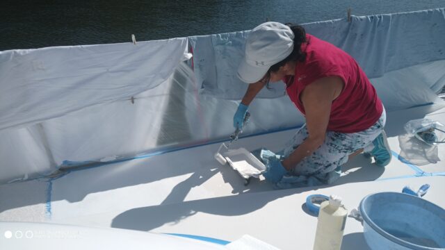
Then sprinkle on the colored chips.
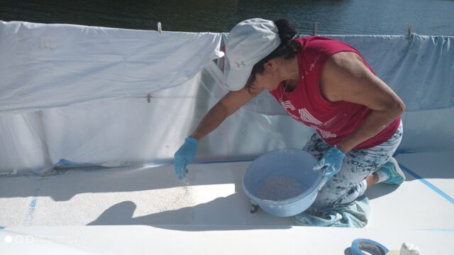
Sand these down very gently just to remove any pointy bits. And finish with a coat of clear colourless aliphatic urethane.
With bare feet on wet decks it is still a bit slippery. But with deck shoes the grip seems to be really good.
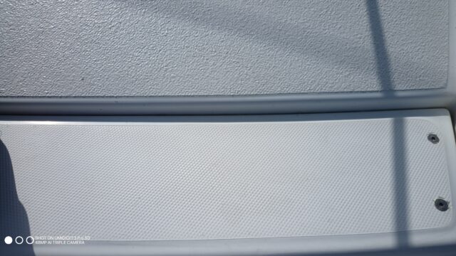
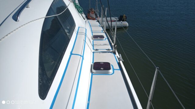
Top is the new Flexstones covering, bottom is the old patterned gelcoat
And it looks really good too. At least it does when it is clean. But it does get dirty easily (as did the old decks), but it takes a bit more effort to clean than the Awlgrip or bare gel coat did.
Still, as it is supposed to last for at least a decade, if not two, we are hoping that the non-skid problem is now solved.
Building Our Hard-Top Bimini
8th Oct, 2024
Our vinyl bimini had done remarkably well, but at 14 years old it was end of life – especially when Ceu put her knee through it. So it was time for a new one, and we decided to build a nice new hard top from scratch. Documented here is the process we went through: Stage (more...)Bahama Blues continues
31st Dec, 2022
Current Location: The Glass Window Bridge, Eleuthra, BahamasCurrent Position: 25 26.11 N 076 36.35 W Click to view map. Distance sailed since last post: 4679 nautical miles. View the map of our voyage track here As soon as we left Staniel Cay we caught a nice mutton snapper, that was exciting especially when were about (more...)Summer 2022 while LP2 rests in Deltaville
22nd Oct, 2022
May 2022 we left the boat in Deltaville US and went home. So sweet to go home to the kids and grandkids! We had a very busy summer with travels that took us to Portugal, Spain, Scotland, England and back to Canada. July 2022 Much fun was had the month of July with the (more...)Fall 2022. US coast before crossing to the Bahamas
8th Oct, 2022
We arrived in Deltaville and did some work on the boat, like paint the bottom. Unpacked all the Amazon goodies we had sent to the Marina. That was great. Being in the States is sure much easier to receive packages. Unlike in the Caribbean where we had to bring it al from Canada in a (more...)How to Use a X-Box Controller with OpenCPN
20th Jun, 2022
We use OpenCPN as our primary navigation tool, running it on a Raspberry Pi 3B using OpenPlotter as the basic platform. Although OpenPlotter has a lot of additional features, we don’t actually use them, just OpenCPN as our chartpolotter. We have an Eyoyo LCD screen at our helm station. It all works well, except that (more...)End of Season 2022 Bahamas to the Chesapeake
20th May, 2022
Last blog left us in Eleuthera in April 2022. We then sailed up to Abacos to wait for a weather window and sail across the Gulf stream to the Cheasapeake. We got fuel and a few fresh vegetables to top us the fridge in Marshtown, April 27th we departed from Man a war Cay, Abacos (more...)Mid-Ocean Live Update
1st May, 2022
Current Location: Mid-OceanCurrent Position: 35 40.88 N 075 15.79 W Click to view map. Distance sailed since last post: 161 nautical miles. View the map of our voyage track hereArrive tomorrow . Sunny today . Still no fish (Sent by InReach satellite connection)Mid-Ocean Live Update
30th Apr, 2022
Current Location: Mid-OceanCurrent Position: 33 15.59 N 076 40.92 W Click to view map. Distance sailed since last post: 159 nautical miles. View the map of our voyage track hereAll is well on board Life Part 2. No fish yet. A bit cloudy today. Doing 11+ kts in the gulf stream (Sent by InReach satellite connection)Mid-Ocean Live Update
29th Apr, 2022
Current Location: Mid-OceanCurrent Position: 30 42.24 N 077 29.81 W Click to view map. Distance sailed since last post: 148 nautical miles. View the map of our voyage track hereStomping along. Blue skies, fast sailing, and the crew even get along! Trying to catch some fish… (Sent by InReach satellite connection)Mid-Ocean Live Update
28th Apr, 2022
Current Location: Mid-OceanCurrent Position: 28 17.2 N 076 56.77 W Click to view map. Distance sailed since last post: 293 nautical miles. View the map of our voyage track hereBeen a lot windier with some big waves. Not as comfortable as its has been, but all is well and we are sailing fast. dont reply to these mesgs (Sent by InReach satellite connection)Arriving in the Bahamas
16th Apr, 2022
Current Location: Stocking Island, Exumas, BahamasCurrent Position: 23 31.52 N 075 46.08 W Click to view map. Distance sailed since last post: 346 nautical miles. View the map of our voyage track here We arrived in Inagua, the most Southern island of the Bahamas, and a Port of Entry, from Luperon. It was a good (more...)Stranded: No Gas, No Phone, No Money, and No Language
4th Feb, 2022
Current Location: Luperon, Dominican RepublicCurrent Position: 19 53.94 N 070 57.16 W Click to view map. Distance sailed since last post: 101 nautical miles. View the map of our voyage track here On Tuesday we rented a car to drive to Puerto Plata to buy groceries for our trip to the Bahamas. It turned out (more...)Notorious thorny path, Mona passage
30th Jan, 2022
Current Location: Samana, Dominican ReplublicCurrent Position: 19 11.8 N 069 19.72 W Click to view map. Distance sailed since last post: 141 nautical miles. View the map of our voyage track here Puerto Rico to Dominican Republic Thursday Jan 20, 2022. Time to head to the DR. But first we need to (more...)Sail To Puerto Rico Chistmas and New Year 2022
21st Jan, 2022
Current Location: Boqueron, Puerto RicoCurrent Position: 18 1.26 N 067 10.68 W Click to view map. Distance sailed since last post: 233 nautical miles. View the map of our voyage track here Puerto Rico here we come! Sail from St Maarten (more...)Bringing the blog up to date Nov 2020 – Dec 2021
23rd Dec, 2021
Current Location: Marigot Bay, St MartinCurrent Position: 18 3.88 N 063 5.7 W Click to view map. Distance sailed since last post: 349 nautical miles. View the map of our voyage track here On our last post Nov 2020 we were looking forward to moving on to Puerto Rico or just straight to the Bahamas. (more...)Getting Ready to go to Bahamas
25th Nov, 2020
Current Location: CarriacouCurrent Position: 12 27.35 N 061 29.54 W Click to view map. Distance sailed since last post: 415 nautical miles. View the map of our voyage track hereThis COVID thing makes planning very difficult. And since we need a new PCR test each time we move, we are thinking the best strategy for the coming winter is to do one long sail to the Bahamas, and then just stay there. No fixed plans yet, but we are thinking along those lines and may well depart on the 900 n. mile voyage in the near future. When we do, this blog will be updated by satellite, complete with our current position. But first we will have to sail back south to Grenada to get our tests done, then we apply for the health visa to enter Bahamas, and THEN we depart. So it won’t happen tomorrow. Will keep you informed.Return to Grenada Oct 2020
12th Oct, 2020
After being in Canada since March, we were anxious to come and check out Life Part. Air Canada cancelled all of their few flights they had available to Grenada during September, and no other airlines were coming in either. Mid-September we booked for Oct 4th / 2020. Many visits to the Grenada Government site online (more...)Back in Canada and quarantine. March 2020
12th Oct, 2020
We left the boat in good hands in St Maarten, on a mooring ball in Simpsons Lagoon, French side. The trip to Canada Through Miami was fine. We arrived at empty airports with employees cleaning everything and every chair. The TV’ was all about the Coronavirus. The world had come to STOP. Everything shut down (more...)Sailing 2020 to Covid19
12th Apr, 2020
Current Location: 18.306854461218883, -65.29860730419921Current Position: 18 18.41 N 065 17.92 W Click to view map. Distance sailed since last post: 126 nautical miles. View the map of our voyage track hereFlying into St. Maarten early Feb 2020 The first thing to do was clean the bottom of the boat. We motored (more...)Christmas 2019 Jan 2020 in Canada
12th Feb, 2020
We arrived in Canada in early December 2019, after leaving the boat in St Maarteen. The ski hills were already open and we got an early start. We celebrated December Birthdays. Noel’s and our grandson Tiago’s. 1 It was the night before Christmas… I think my (more...)Adventures continued from November and December 2019
12th Jan, 2020
Current Location: 18.057599168193846, -63.11244216464844Current Position: 18 3.46 N 063 6.75 W Click to view map. Distance sailed since last post: 129 nautical miles. View the map of our voyage track hereWow…time to catch up where we left off last November 2019. In October we joined Life Part 2 in Trinidad where we had left it (more...)Hiking adventures
10th Nov, 2019
Boiling Lake, Dominica One of the toughest and most famous hikes in Dominica is to the Boiling Lake. We had done this hike ten years ago, but we knew we had to include it again on our pass through the island. We love (more...)Tying the Knot in BVI after 9 Years
11th Jun, 2019
Current Location: Deshaies, GuadeloupeCurrent Position: 16 18.65 N 061 47.38 W Click to view map. Distance sailed since last post: 206 nautical miles. View the map of our voyage track hereJune 1st. It was nine years ago, today, that Ceu and I flew out from Vancouver to here, British Virgin Islands (BVI) to pick up (more...)Sailing 2019 – Snorkeling and Deserted Beaches
11th Jun, 2019
This year we did a mad dash all the way up from Trinidad to BVI, and now we are heading back down to Trinidad. That’s about 450 nautical miles each way. We covered a lot of islands, a lot of beaches, and saw a lot of fish. We even caught a few! And we have (more...)Dyneema Rigging – Would I Do It Again?
24th May, 2019
Current Location: Guana Island, British Virgin IslandsCurrent Position: 18 28.41 N 064 34.61 W Click to view map. Distance sailed since last post: 421 nautical miles. View the map of our voyage track hereIt is time for s/y Ventus to have new rigging. So our friend Nick asked me if, starting from stainless rigging, I (more...)What do we do in Canada, home away from home
8th Apr, 2019
Snow, hey??? We Ski ( we do have a Summer as well) Deep snow,ungroomed slopes Snow shoeing and dog sleding Family time… Birthdays parties, and beach time in our local Lakes Lots of special moments like the first day of school. Little one wants to go too! (more...)Update Spring 2018- Guadaloupe to Barbuda
21st Mar, 2019
Current Location: English Harbour, AntiguaCurrent Position: 17 0.54 N 061 45.8 W Click to view map.Continued from spring 2018 Guadaloupe to Trinidad Wow…I can’t believe it has been a year since my last post. As promised here is Guadaloupe Part2, showing you more of our beloved French island. Not only we enjoyed the wine the (more...)Arrived in Grenada
14th Mar, 2019
Current Location: Prickly Bay, GrenadaCurrent Position: 11 59.91 N 061 45.79 W Click to view map. Distance sailed since last post: 79 nautical miles. View the map of our voyage track hereIt was good to get out of Chaguaramas. It is a great place for getting work done, but not for chillaxing, being very industrial. (more...)Back on the Water – Finally!
13th Mar, 2019
Current Location: Chaguaramas, TrinidadCurrent Position: 10 40.95 N 061 38.04 W Click to view map. Distance sailed since last post: 0 nautical miles. View the map of our voyage track hereIt has been a long time. We arrived in Trinidad at the end of June 2018 to leave the boat on the hard for the (more...)I have waited 41 years to get one of these…
22nd Oct, 2018
Current Location: Vernon, BC, CanadaCurrent Position: 50 15.36 N 119 17.39 W Click to view map.So now with the big 60 approaching, it is with great excitement that I can reveal that it has finally arrived… She has been christened Sally, after the red MG Midget that I owned when I had just graduated (more...)Martinique and the rest of Season, May-June 2018
23rd Jun, 2018
Current Location: Chaguaramas, TrinidadCurrent Position: 10 40.74 N 061 38.34 W Click to view map. Distance sailed since last post: 332 nautical miles. View the map of our voyage track hereAs I prepare some new photos from our travels 2019, I get reminded that I must finish catching up with last year. We said goodbye (more...)Off to Guadaloupe
19th Mar, 2018
Current Location: Islet du Gosier, GuadeloupeCurrent Position: 16 12.1 N 061 29.6 W Click to view map. Distance sailed since last post: 130 nautical miles. View the map of our voyage track hereA bit of an update. . It was fun to visit once again some of our favourite spots in St Lucia and (more...)Now THAT is Why We Go Sailing
2nd Mar, 2018
Current Location: Rodney Bay, St LuciaCurrent Position: 14 5.4 N 060 57.74 W Click to view map. Distance sailed since last post: 23 nautical miles. View the map of our voyage track hereOn Wednesday we finally had our new forestay and furler fitted, and we managed to escape. Enough of boat maintenance for a while. (more...)Mais Oui, Toute Marche!
10th Feb, 2018
Current Location: Le Marin, MartiniqueCurrent Position: 14 28.08 N 060 52.51 W Click to view map. Distance sailed since last post: 23 nautical miles. View the map of our voyage track hereYep, (almost) all is working now. We needed some different scenery, and we desperately needed to stock up on cheese, salami, and wine, so (more...)Fixing Boats in Exotic Locations
7th Feb, 2018
Current Location: Rodney Bay, St LuciaCurrent Position: 14 5.42 N 060 57.67 W Click to view map. Distance sailed since last post: 1 nautical miles. View the map of our voyage track herePeople say that cruising is actually better described as ‘fixing boats in exotic locations’. We can attest to that. Since we got back (more...)Back On Board in St. Lucia
27th Jan, 2018
Current Location: Rodney Bay, St LuciaCurrent Position: 14 4.34 N 060 57.48 W Click to view map. Distance sailed since last post: 0 nautical miles. View the map of our voyage track hereYes, we are back. After a very pleasant 6 months in Canada, including canoeing, hiking, an Alaska cruise with my Mum, and skiing, (more...)Dodging Irma
15th Sep, 2017
For the past week we have been canoeing in the Bowron Lakes in mid BC. What an awesome week, even though we had all sorts of weather, including rain – but thankfully no mosquitos! Meanwhile Life Part 2 was sitting safe and sound in St. Lucia. When we left for Bowron we knew that Irma (more...)BOAT = Bring Out Another $Thousand
29th May, 2017
Current Location: Rodney Bay, St LuciaCurrent Position: 14 4.32 N 060 57.52 W Click to view map. Distance sailed since last post: 214 nautical miles. View the map of our voyage track hereIn Barbuda our windlass gave up on us. Well, actually, it was a combination of two things: our anchor chain was rusty and (more...)Racy Photos from Martinique
15th May, 2017
Current Location: Cocoa Point, BarbudaCurrent Position: 17 32.95 N 061 46.18 W Click to view map. Distance sailed since last post: 32 nautical miles. View the map of our voyage track hereAlthough we spent quite a bit of time in Martinique we didn’t write much about it, only a few photos of the Carnival and (more...)Sailing the Most Beautiful Yachts in the World
25th Apr, 2017
Current Location: Falmouth Harbour, AntiguaCurrent Position: 17 1.14 N 061 46.36 W Click to view map. Distance sailed since last post: 183 nautical miles. View the map of our voyage track hereShe is 78 years old but, as befits her name, still as hot and sexy as a prom queen. Helped, no doubt, by the (more...)Beautiful Saint Lucia
11th Apr, 2017
Current Location: Rodney Bay, St LuciaCurrent Position: 14 4.34 N 060 57.53 W Click to view map. Distance sailed since last post: 36 nautical miles. View the map of our voyage track hereEnjoying Saint Lucia We are delighted with beautiful sunsets every evening from our anchorage in Rodney Bay. Noel enjoying a nice swim (more...)Still in Martinique
6th Mar, 2017
Current Location: Case Pilote, MartiniqueCurrent Position: 14 38.48 N 061 8.41 W Click to view map. Distance sailed since last post: 114 nautical miles. View the map of our voyage track hereWell, here we are still sitting in Martinique! Ceu has been to Canada and back to see the grandchildren. Now my sister, Mitzi, and (more...)Mid-Ocean Live Update
31st Jan, 2017
Current Location: Mid-OceanCurrent Position: 13 20.24 N 059 42.9 W Click to view map. Distance sailed since last post: 6 nautical miles. View the map of our voyage track hereJust left Barbados for a quick over night reach to Martinique. Will do full update when we get decent internet (Sent by InReach satellite connection)Mid-Ocean Live Update
28th Jan, 2017
Current Location: Mid-OceanCurrent Position: 13 15.93 N 059 38.81 W Click to view map. Distance sailed since last post: 19 nautical miles. View the map of our voyage track hereArrived in Barbados . Drinking wine. (Sent by InReach satellite connection)Mid-Ocean Live Update
27th Jan, 2017
Current Location: Mid-OceanCurrent Position: 13 23.09 N 059 20.34 W Click to view map. Distance sailed since last post: 292 nautical miles. View the map of our voyage track hereLand ahoy…I see land !!! Arrival is near! Caught 2 more fish and had our first squall all at the same time. Lots of excitement. Looking forward to rum punch! (Sent by InReach satellite connection)Mid-Ocean Live Update
25th Jan, 2017
Current Location: Mid-OceanCurrent Position: 13 44.87 N 054 20.76 W Click to view map. Distance sailed since last post: 82 nautical miles. View the map of our voyage track hereNot much wind, have slowed down. New ETA Sat. Maybe. Who knows? Nice weather though . (Sent by InReach satellite connection)Mid-Ocean Live Update
25th Jan, 2017
Current Location: Mid-OceanCurrent Position: 13 50.09 N 052 56.16 W Click to view map. Distance sailed since last post: 211 nautical miles. View the map of our voyage track hereIt is late at night, and the stars are shining brightly. So beautiful! Wind finally picked up, so doing 7 Kts again. 400 miles to go. ETA Fri eve, we hope. (Sent by InReach satellite connection)Mid-Ocean Live Update
23rd Jan, 2017
Current Location: Mid-OceanCurrent Position: 14 6.18 N 049 19.12 W Click to view map. Distance sailed since last post: 137 nautical miles. View the map of our voyage track hereyummy…some nice hot chocolate. Burgers on BBQ. Bouillabaise, fresh bread. Gourmet dining at Heavenly Delights. One yacht in sight. Wish you were here. 🙂 (Sent by InReach satellite connection)Mid-Ocean Live Update
22nd Jan, 2017
Current Location: Mid-OceanCurrent Position: 14 17.51 N 046 58.75 W Click to view map. Distance sailed since last post: 150 nautical miles. View the map of our voyage track hereNot much wind, have slowed down. Now playing a domino game, mexican train. Ceu knitting scarves and dreaming of visiting grandkids in Canada soon. (Sent by InReach satellite connection)